Picture
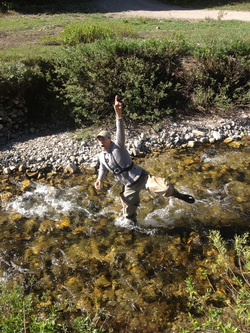
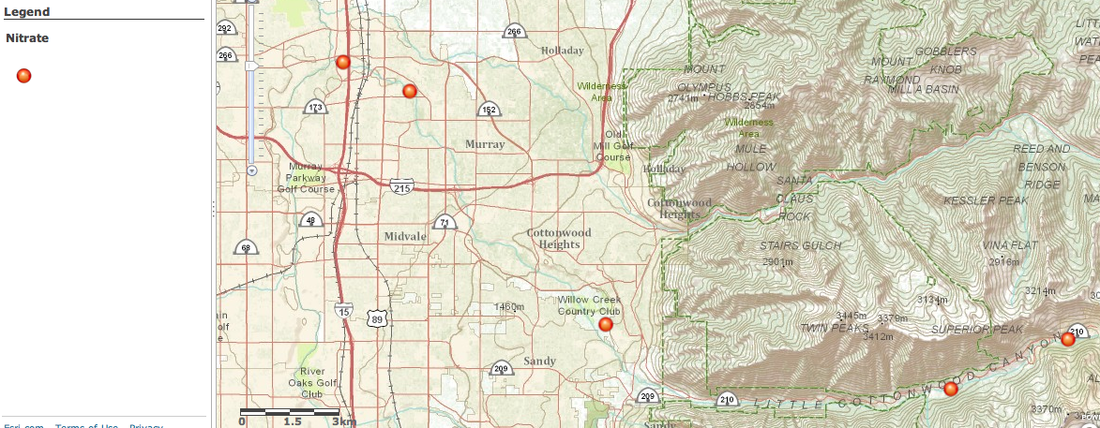
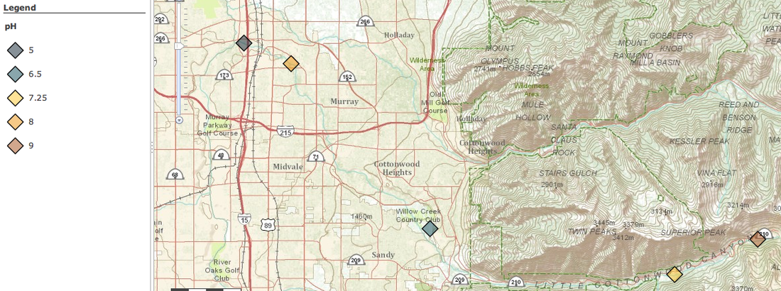
Summer's day fieldtrips... Never thought i would be on a school bus in the middle of summer break. Luckily, this field trip took us to Albion Basin, on of my favorite summer haunts.  Our initial measurements where taken at the base of the Collins and Wildcat ski runs at Alta.  The frigid water, though refreshing, caused my hand to go numb while taking the pH.  It was fun. We met a few individuals who work at Alta.  Maura, a sustainability coordinator, offered to help us with field trips and possibly early access up the summer road for some hiking.  It was fun to meet individuals who are so willing to help and assist in educational endeavors. 

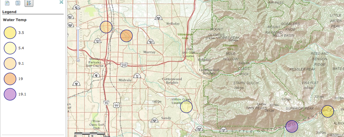
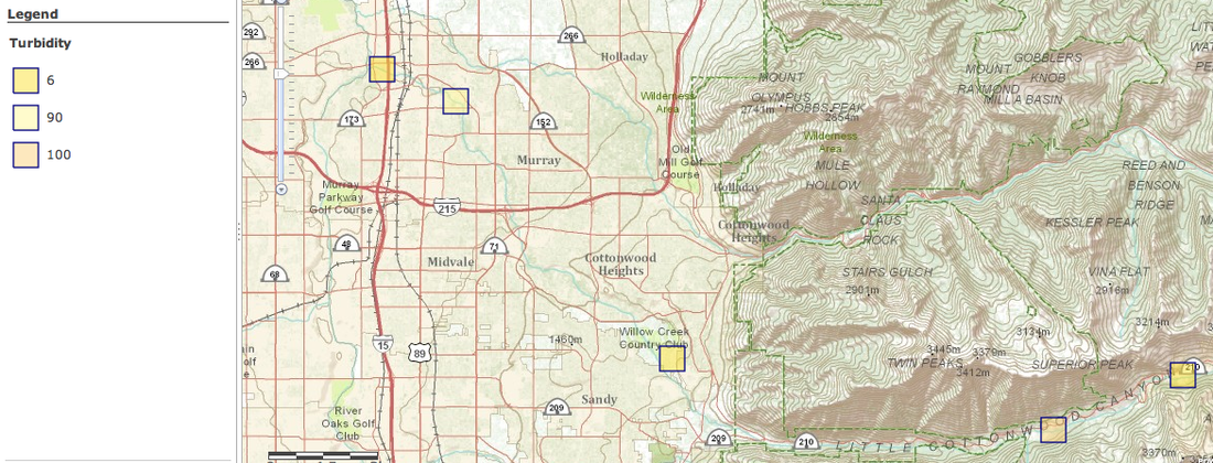
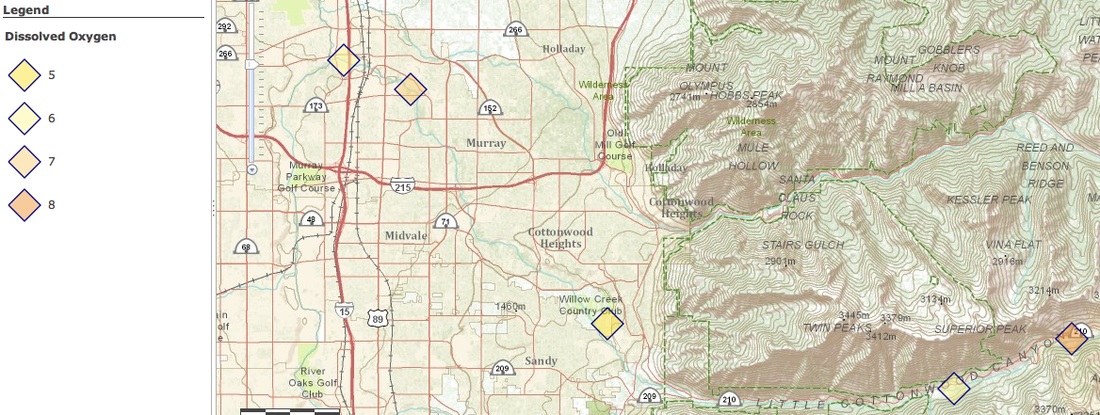
As we went down Little Cottonwood Canyon, the water samples became less and less scenic and clean.  By the end, the water quality was filthy.  It was amazing to see the difference in how excited and willing people where to get in the water at the beginning of trip.  By the end, very few entered the dirty/polluted water, and those who did, were not pleased by the smell coming from their feet.  

The implementation of the data had a few snags, but with the help of our faithful Ed Techs were there to save the day.  I enjoyed adventure, and the fun with the GPS.

Picture
Picture
Picture
Picture
Picture

Interactive Map

 
Picture
Today was a lot of catch-up for me.  Luckily, I have some incredible individuals who are able to help and assist me.  I created my initials utilizing the GPS unit and the tracking application.

Tree Mapping Project: Using our GPS units, a GoPro, iPads, and ingenuity, we mapped out the trees on the south end of the Alta High School grounds.  Trees varied in height, width, and variety.
Some of the trees were slightly tricky to identify and measure.  Rather than making a triangle/ratio of measurements in comparison to the shadows, we took the measure of Danae (5'7) walked back till the GPS unit appeared the same size as Danae.   Then we simply counted the amount of GPS units till it reached the top.  This gave us a fairly accurate estimate of each tree's height.

Stream Side Science is a workbook that has information and lesson plans we can use with our classrooms.  It was mentioned that we can get this for free as a PDF online, or talk to Utah State University and pay a mere $16.00 for a hard copy.
Watersheds: During the presentation, I loved the kinesthetic/visual representation of cupping your hands and showing where the water starts (thumbs) and ends (pinkies). ...."we all live downstream."

The 'field trip' to Little Cottonwood Canyon should be fun.  Testing the water should be interesting.

Tree Hunt Interactive Map

Picture
Picture
Picture
 
I recently bought a house, and had the mass-moving day on the 18th.  Incredibly busy.  Sadly, I wasn't able to attend the class with everyone.  After reading the the agenda found the the CANVAS modules, I signed up and reviewed: GARMIN Basecamp, CMAP ArcGIS, Past CMaP Projects, Geocaching Ideas, Utah Geographic Alliance, Map books from ESRI, GIS mailing list,  and collaborated with Danae on our group project.

I also used the Tracking feature on the GARMIN etrex 20 to make my initials.  Below is an embedded map to see where I completed this assignment.
 
Picture
Today we each received a GARMIN etrex 20.  We did some minor waypoints, both plotting and discovering.  After the direct instruction of using the device, we went outside and did a "scavenger hunt".  During the scavenger hunt, Danae and I also utilized some features of the GoPro Hero3.  I learned that when creating the waypoint, I should place the GPS device directly on the item or location. I am excited to use this!!!

We also looked over a variety of maps.  Some of the websites appeared to be incredibly useful and informative.  With the plethora of maps that are available, it could be overwhelming trying to find the types of maps that would be beneficial or applicable to the classroom.  I guess this is where the instructors/teacher s come into play.  We look through the maps, decide which would be useful in the classroom, and share these with the students.  

The brief introduction of GEOCACHING  was informative, but barely touched the surface.  In questioning about types of geocahing to do, I learned that there is a great app available on the iPhones.  Sadly, only the Ed Techs are included in the purchase of this app.  Good news is that as a "highly paid" teacher, I can easily afford this myself.